 Last night I generated a campaign map and a graph showing how major sites of interest link to each other.
I have 26 nodes at my highest level, and I usually stick to a total of 10-12 nodes in any given graph for a particular level of detail and locality (such as the Node-Based Megadungeon — 11 regions at the highest level, followed by usually 8-10 areas inside each made for somewhat more than a hundred nodes, but less than a dozen that I had to be aware of at any given time). This feels simultaneously like a lot of nodes (more than I usually work with) and not very many nodes (these 26 nodes are expected to cover, to some degree, the entire hex map).
Time for a quick sanity check. The hex map is 80×80, and 80 is quite close to 3*26. Assuming even distribution, each of my initial 26 nodes might represent a region of 240 hexes, which is a region about 15-16 hexes across. Assuming the nodes in the graph are physically located in the center of each of these regions, on average we’re looking at about 90 miles, about four days travel, between them. In terms of area, 240 six-mile hexes comes to about 7,500 square miles. Vancouver Island is about 12,000 square miles, 7,500 square miles is about as big as I’d want to try to capture as a single node. In practice I might even end up having each node represent a smaller region because about half the map is water anyway.
Okay, looks sane. I like it when that happens.
Now to start looking at where the various nodes in the graph land on the hex map.
Physical Placement
I have concluded that the graph is primarily focused on sites of interest rather than actual adventures or scenarios. Given the size of the region each represents I have to expect there are multiple stories that could be told in each.
So, nodes have physical locations, and the edges represent relationships between them. Where there are two edges the relationship is likely complex, such as having multiple factions on each side each having relationships with factions on the other side.
First, let’s try the obvious: set the images to the same scale and put the graph on top of the hex map.
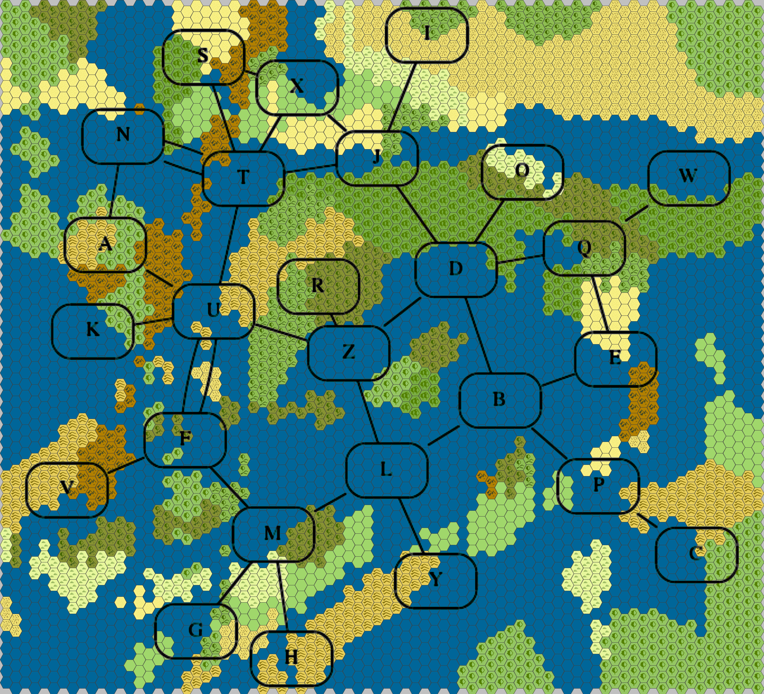
Mmm… nope, not quite. On a different map, probably one with more land, this might have worked. Without counting precisely, it looks like perhaps a quarter to a third are mostly water, and the rest are split fairly evenly between “a mix of multiple land types”, and “land plus water”. However, I also see large chunks of land with really nothing in them, and that doesn’t seem right. I think I’ll have to go to manual placement.
As it happens, I posted the above image as a draft to G+ and the feedback I got suggests it’s actually not as unworkable as I initially thought. I still want to make some changes, but they are more along the lines of refinement of the initial layout and not doing over entirely. For instance, ‘node B’ is going to be moved onto the island inside ‘ZDBL’. I have a strong Mediterranean feeling here, with that island being in a position much like Crete.
Incidentally, that suggested this map is too small, but the next step up that I use — 24-mile hexes — takes this map from “about 55% the size of British Columbia” to “80% the size of Canada”. That’s somewhat more than I really want to deal with.
Here is a second run at it. The nodes still aren’t perfectly positioned, but it’s kind of wibbly-wobbly anyway.
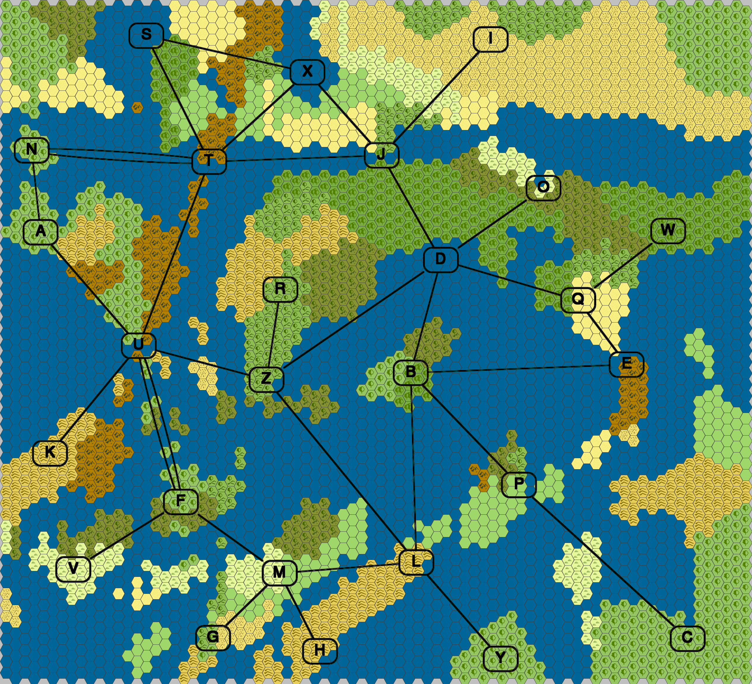
Evidently in laying the graph out by hand I changed something that causes the nodes to be a bit smaller (the font change was deliberate, though). The size difference doesn’t much bother me because I think as I continue to work on this I will be putting proper names in the nodes instead of letters, so I can use the extra space anyway.
Not all are quite where I expect them to end up. I will likely adjust them as I go, especially as I get a better feel for what is at each location.
- S should move down a bit,
- N might move up,
- A might move to the right,
- T might move out of the mountains to the forested hills to the southeast,
- D was supposed to be a bit higher,
- same with Q,
- O may move a bit to the northwest,
- ditto W, and
- I’m not sure I like C where it is.
- I considered moving E, but I’m still digging on the idea of dwarves in ironclad — make B the meraelves with their windships and stormkites at B and that explains the B-E relationship.
Still, it’s pretty clear to me that PCs are likely to spend a fair bit of time on boats if they’re going from node to node. Not so much if they’re staying in one place, but if they leave town there’s a good chance boats are involved. This is an interesting departure for me, usually I stick to land-based stuff.
Okay, this is shaping up well. I’m not entirely sure where I’m going with everything, but that’s okay. I can start expanding on things tomorrow.
Thoughts on a couple of those nodes:
T: I’d say keep it there or move it to the north end of the island just to the south. That’s a rather potent position to be in, (especially if there is trade flow from node N or S to points in the south or east). This gives it a good reason to be so connected and it links nicely with U and F being the other big gateways.
C: Having an out of the way node there makes sense to me. Perhaps it’s a resource colony, with the elves at B dealing with L and P for the better and more plentiful timber to be had in the southeast.
I was thinking T might find more usable resources on the forested hills, but you have a point. As for C, I was thinking about moving it a bit to the east and up the coast a little bit — same landmass, just a little bit further up.
I was also going to suggest moving T south to the mountainous island.
(speculation follows)
The island is named Stormhame. The ancient line of the Thunder Kings once harnessed the potent magical energies of the skies in this place, and kept the surrounding areas under their rule. Although Stormhame’s influence has waned since the end of the Thunder Kings’ line, they are still a big player: they are active in the political arena, and the island also remains the home of the Shrine of Ferocity and its priests.
I had not yet given it that much thought, but sure, let’s go with it. It sounds pretty cool and I can see some hooks to it.
I didn’t think you were at that level yet, but it was one of those things where an idea pops into my head and I had to write it down!
PS: I still can’t log in with Firefox on Windows
Weird. I’m using Waterfox (64-bit Firefox) in Windows 7 and it works fine.
And yeah, I’m not consciously thinking about these in detail yet, but as ideas come to me (or are delivered) I note them. In fact, tonight’s post is “High-Level View of the Sandbox”, where I start to assign meaning to the nodes and edges.